Tuesday, August 13, 2013

Forests and Climate Mitigation in New Hampshire


Forests and Climate Mitigation in New Hampshire:

Valuing the Climate Benefits of Forest Ecosystems in the Granite State


Delegates at the Doha UNFCC meeting in 2012
The world's governments are currently assessing how to respond to and prevent changes to the Earth's climate from the extensive release of greenhouse gasses (GHGs). For several decades, countries throughout the world have set together a series of agreements to limit their overall emissions of GHGs. A good example of a longstanding agreement amongst several countries to do this can be found in the United Nations Framework on Climatic Change and the Kyoto Protocol. This treaty essentially binds certain countries to reduce their emissions by a set time period. There are several market mechanisms within the Kyoto Protocol by which countries can exchange and offset some of their emissions, from emissions trading to the development of projects that sequester or reduce GHG emissions which then generate emissions credits. Policies set to reduce GHG emissions exist on other levels, too, from cities to groups of states to over-the-counter exchanges.


Since trees are large carbon storage vessels, incorporating forests into GHG emission reduction platforms has been promoted as a method that serves additional conservation and preservation benefits.  In general, when forests are valued for their ability to sequester and store carbon, they often are more valuable left standing than harvested and processed, particularly in tropical areas where carbon storage can be great. As a result, forest land-owners have been particularly involved in trying to obtain funding for the carbon sequestration capabilities and climatic benefits of their trees. While such payments-for-ecosystem-service mechanisms involving forests do not exist in the Kyoto Protocol currently, similar transactions have been incorporated into other emissions reductions agreements (i.e. the California Environmental Protection Agency's Air Resources Board Compliance Offset Program).

Ecosystems such as forests also provide additional climatic benefits than through carbon sequestration and storage, however. Albedo is described as a unit-less index ranging from zero to one which describes how well a surface can reflect incoming radiation. Ground that is covered by snow is highly reflective and has an albedo that approaches a value of 1.0. A dark surface, such as a Spruce forest, often has a lower value of albedo, approaching 0.10. When incoming solar energy in the form of ultraviolet light hits the Earth's surface, it is either reflected back into space, or is absorbed and re-emitted as heat which is trapped by the greenhouse layer. Thus, brighter and more reflective surfaces, such as snowy ground and sea ice cover, help provide climate-mitigation services.

The White Mountain National Forest, New Hampshire
Forests in northern latitudes which receive snow regularly throughout the winter therefore provide two different climate-regulating ecosystem services: carbon storage and albedo reflectance. Our recent research for the New Hampshire EPSCoR project examines forests in the White Mountain National Forest and these benefits in the context of different management strategies and economic values. Primarily, we were interested to see what happens when the benefits of albedo were valued, since in all climate mitigation platforms forests are solely valued for their carbon storage. Forest albedo benefits are realized when forests are cut and snow is allowed to accumulate on bare ground, whereas carbon benefits are realized through the growth of forest trees. Therefore, when both of these services are valued, there are tradeoffs that may occur by harvesting trees at different times. This information is very important for future planning of forests in New Hampshire in the new era of climate mitigation.

Snowfall as viewed by the MODIS sensor
Figuring out how these properties of services and the economics balanced out required the extensive use of computer models. Using a model of the world's economy called DICE, which is classified as an integrated assessment model of the climate and the economy, we calculated the potential climatic damages on the economy due to climate change. We were able to construct shadow prices for both carbon storage as well as the energy that is reflected through albedo. We then used these prices to determine the total revenue streams by simulating the growth of forests in a computer model. We simulated albedo over time by looking at historical measurements of albedo taken by NASA's MODIS instrument which flies on board two satellites and takes images of the Earth continuously.

High altitude spruce-fir forests in the White Mountains
The results of this research indicate that the climatic benefits of albedo are quite important. When only carbon and the revenue provided by timber harvest are considered, most forests in the White Mountains should be maintained standing, with infrequent harvest. However, when there is an economic value for albedo, the benefits of harvest become more significant. In some high-altitude spruce-fir forests the albedo effect is so valuable that it is most economical to harvest trees frequently so as to maximize the climatic benefits of albedo. Although our project has only looked at a small area within the White Mountains, we intend to expand this analysis throughout the state. This will provide us with a guide as to the management strategies that may provide the biggest economic and climatic benefits of our forests.    Future work on this research will also incorporate the influence of climate change on the quantity and timing of snowfall, and how that may influence management in the context of albedo.

Posted by David Lutz, Research Associate,  Environmental Studies Program, Dartmouth College

Wednesday, July 24, 2013

What Will the Future Look Like?

From assembling a shopping list for a weekend party to building a house or growing a business, there are dozens reasons to want to know what the future will bring. Yet, uncertainties abound. People forget to RSVP; paperwork gets held up; construction is delayed due to weather. Under normal circumstances, we predict the future by thinking about the past, whether recalling our own experiences or drawing on the lessons of others. But how do we plan when the world itself is changing? As our society grapples with the social, economic, and environmental changes of the 21st century, more creative approaches are required.

Planning natural resource use in New Hampshire is no exception. To try to tackle this problem, my collaborators and I use a variety of tools to develop educated guesses about how New Hampshire's changing landscapes will affect quality of life for New Hampshire residents. Computer simulations are essential, but no computer can predict how human behavior will change. To answer that question, our team arranges conversations with a broad variety of New Hampshire residents. By talking to people today, we hope to develop narratives about alternative futures: different stories of how land use might change in the century ahead.

The ways that human activities will shape New Hampshire landscapes depend not only on the state's economic growth and movement of people into or out of the state, but also on individual values and goals. Some prioritize conservation and tourism. Others want to ensure local food production to maximize resilience to global disturbances and minimize fuel consumption associated with transporting food over long distances. Still others focus on ways to increase energy independence through expanded use of biomass, wind, and hydroelectric sources of power. All of these visions have merit, but the question remains open of how the 6 million acres of New Hampshire will be allocated over the century ahead: choices must be made about the degree to which each piece of land will be used for food production, energy production, housing, manufacturing, recreation, conservation, or other purposes we might not now foresee.
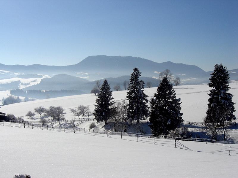
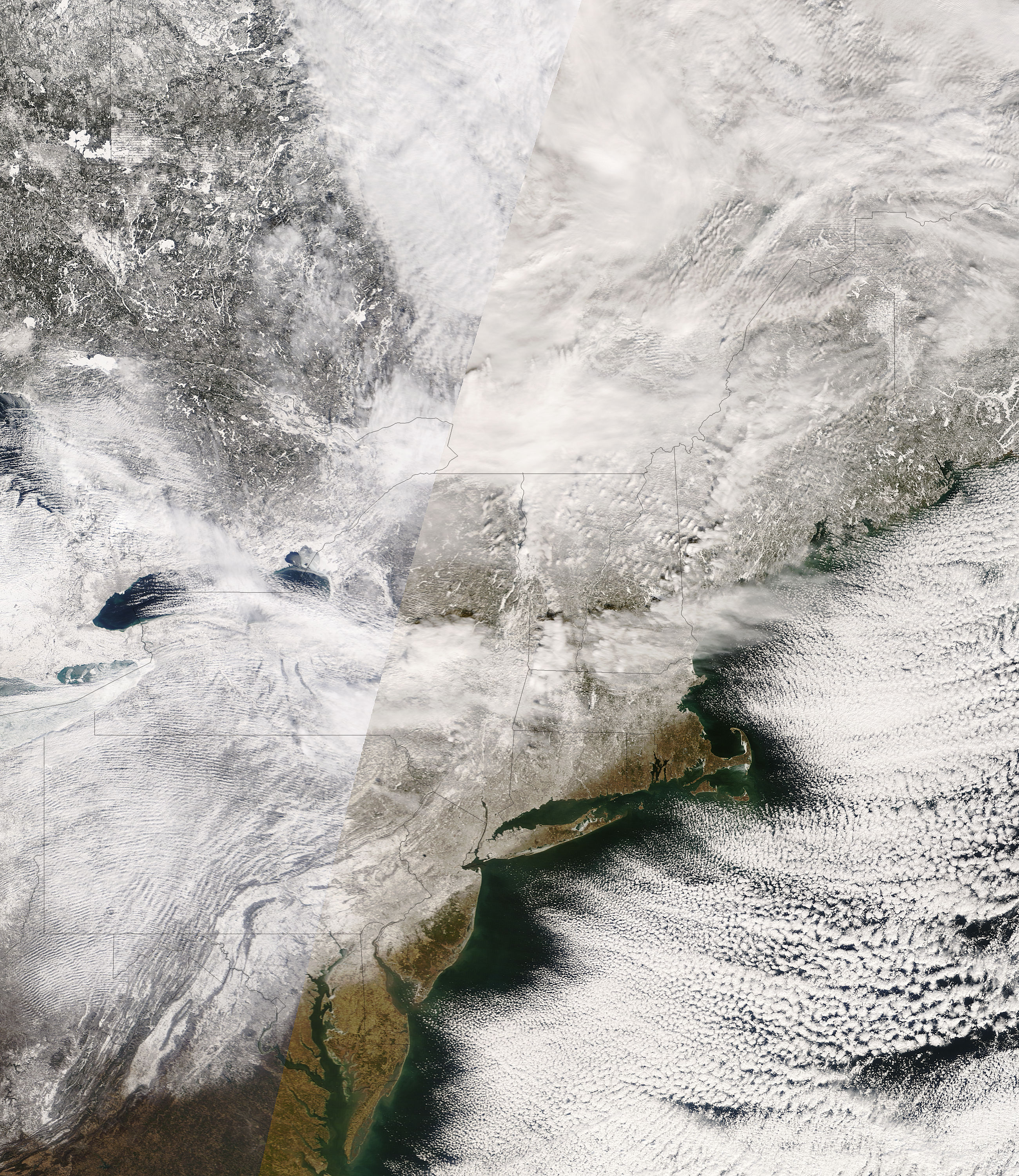
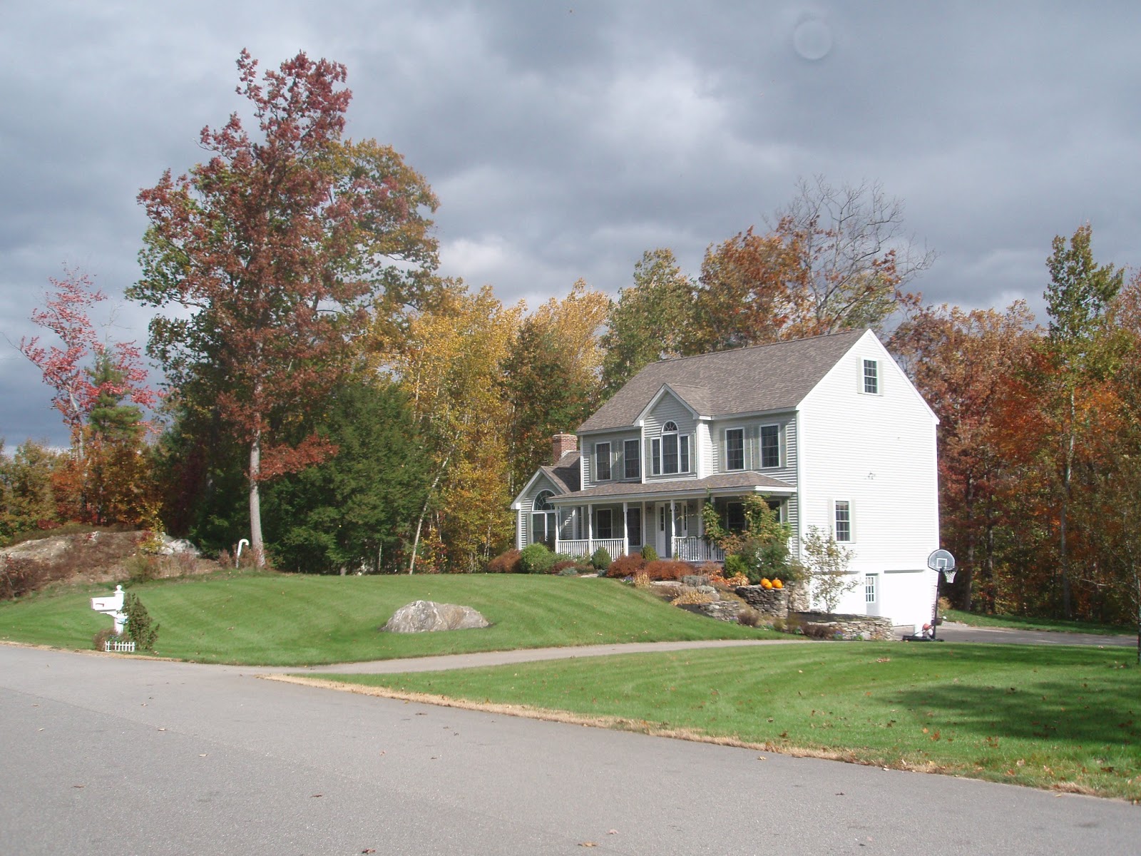
Credit: Wikimedia CommonsCredit: Wikimedia CommonsCredit: http://www.voyagesphotosmanu.com/


In addition to the diversity of values shaping land use change, we must also consider ways that the future many people hope for could be made more or less possible by a range of external economic, political, and environmental factors. For instance, although some conservationists and some entrepreneurs may hope for higher density urban centers to attract businesses and reduce the impact of suburban sprawl, this style of development would require a sea change in municipal zoning policies in most New Hampshire communities. Similarly, expansion of the ranges of plant pests and diseases due to climate change could limit both conservation and food production, while the decline of winter sports could reduce the number of tourism-related jobs and ultimately limit resources available for growth. On the other hand, at the continental scale, people might choose to relocate from areas of the United States strongly affected by droughts and heat waves to cooler and moister states, including New Hampshire, and the resulting population increase could stimulate growth and development.

As our team works to develop plausible alternative scenarios for future land use in New Hampshire, we hope to incorporate both human desires and external constraints into our narratives.  We hold open discussions with groups representing the diversity of New Hampshire residents, including developers, planners, and conservationists, as well as representatives of state agencies and a variety of businesses likely to shape and/or be affected by future changes in land use.  In these discussions, we ask participants to respond not only to the question of what they hope the future of New Hampshire will be like, but also what they expect and what they imagine might happen as a result of external drivers.  Through these questions, we tap into not only their values, but also their expertise.

The narratives we develop will serve as input for computer simulations, which in turn will provide a basis for decision-making by businesses, organizations, government agencies, and individuals, including many of the groups whose perspectives we are soliciting.  Just as importantly, our questions about what the future could look like and our simulations of how alternative futures could affect ecosystem services serve as a starting point for discussions about how we as New Hampshire residents can shape the future of the state.  By having these conversations now, we help to ensure that the New Hampshire landscape in the century ahead will continue to provide for the needs of safe, beautiful, vibrant communities, including clean water, affordable energy, and beautiful surroundings.

Posted by Alexandra Thorn, Post-Doctoral Research Associate, Earth Systems Research Center, University of New Hampshire

Wednesday, July 17, 2013

Cutting edge environmental monitoring comes to New Hampshire

Sensors have become an integral part of our daily lives, from thermometers to networks of wireless humidity sensors used to monitor fire danger in remote forests.  Sensor technology is advancing rapidly, becoming easier to use and to maintain, allowing us to push the boundaries of scientific research.  Recently, this has become international news with the sensor technology on the Rover now deployed on the surface of Mars.  This technology is advancing rapidly in the ecological sciences and is now allowing us to measure parameters in soils and rivers as accurately as we can in the laboratory.  At the same time, the technology for wireless communications and solar power has also advanced and become more affordable enabling us to connect sensors directly to our research labs and monitor the environment in remote areas in real-time.

One of the key ecological questions facing New Hampshire is, "What impacts are land use and climate change having on ecosystems throughout the state?"  To help answer this, we have been developing and maintaining a state-wide network of soil and water sensors as part of the New Hampshire EPSCoR program.  The sensors network will be capable of delivering fine time scale data, which will enable a better linkage between responses in headwater systems and the impacts on the larger river drainage networks.  It is our aim to link soil processes to water chemistry parameters by co-locating terrestrial and aquatic sensor sites wherever possible.  The data we gather will provide modelers with resources needed to develop scenarios for future change, which can be used by teachers, interested citizens, or environmental managers wanting to learn more about watershed systems in New Hampshire.


A sensor network is designed to transmit the data from an array of sensors to a data repository on a computer server.  In the case of both our soil and aquatic sensor networks, various sensor nodes are deployed and are connected to a datalogger that stores the data and is programmed to tell the sensors when to collect data.  This system is powered either by hard-wired electricity or by batteries that are charged by solar panels.  The data is then transmitted by cell phone modems back to NH EPSCoR’s data server.


Soils Sensors 

With our complex soil sensor system, we have an array of sensors that examines how soil properties and processes change as climate in the region changes by monitoring soil carbon (C) at multiple sites across the state. At each one of our sites we have six chambers which automatically detect the CO2 being respired by soil microbes using an infrared gas analyzer.  Paired with each chamber we have three soil sensors installed at the soil surface and fifteen and thirty centimeters below the surface, which detect temperature, moisture content and electrical conductivity.  We collect basic weather data at each site as well, such as air temperature and precipitation amounts.  By understanding how extreme weather events affect soil properties and processes as well as stream chemistry, we can predict the likely effects of climate change on soils and water quality in the coming decades. 


Aquatic Sensors

The aquatic side of the sensors network is comprised of two main instruments: (1) The EXO2 by YSI is a multi-parameter water chemistry instrument, with interchangeable sensors capable of measuring pH, temperature, dissolved oxygen, conductivity, turbidity, fluorescent dissolved organic matter (fDOM – a surrogate for dissolved organic carbon), and (2) the Specific Ultra-Violet Nitrate Analyzer (SUNA) by Satlantic, which measures nitrate concentration.  We are also collecting river flow data to help determine patterns with weather events and climate change. The sensors sample the selected stream and river sites every 15 minutes. Data on this time scale will give researchers a detailed look into how streams respond to differing types of land use or management, as well as changes with storm events.

EXO2 multi-parameter sonde, by YSI

Specific Ultra-Violet Nitrate Analyzer (SUNA), by Satlantic


Sensor and communication technology has advanced rapidly in this field, where this kind of work could not have been done this way 10 years ago. In the case of one of the sensors, the SUNA can detect nitrate almost as low as we can back in the lab and is a significant advancement from previous sensors that had detection limits several times higher. It is also relatively maintenance free. A wiper keeps things from collecting in the sample path and a copper guard keeps microbes in check. The wireless communications are so good that we now can communicate with all of our sensors even in remote areas of the White Mountains. This is an exciting time in our field and the quantity and quality of the data we produce will help push our understanding of our environment. In our next post we’ll let you know what the challenges we face when installing the sensors.

   
Sensors suite ready for deployment


Posted by Jody Potter, Analytical Instrumentation Scientist III; Brian Godbois, Senior Laboratory Technician; Lisle Snyder, Laboratory Technician II
Natural Resources & the Environment, University of New Hampshire


Wednesday, July 10, 2013

Science Education Gets Real at Sanborn Regional

Bridging New Hampshire's science education gap through project-based learning


"Science is dirty!" "It’s too hard!" "We don't have the tools we need!" Sound familiar? These were a few of the comments by sophomores from Sanborn Regional High School working at local Powwow Pond as part of an intense semester long project.
Sarah Sallade, a 10th grade Life Science teacher at Sanborn, says that such complaints naturally arise when students experience what it's like to be out in the field collecting their own data – sans the spoon feeding of information they are accustomed to. “In real life, doing research is messy, you don't always have all of the information or funding for the most advanced resources, and sometimes you have to improvise,” says Sallade, who holds master’s degrees in both natural resources and education from UNH. “This project is interesting because it's a different approach," says Sallade.

And she would know. Her master's research involved carbon cycling of forests of the northeastern U.S. From 2006-2012, Sarah primarily worked to translate terrestrial carbon cycle research into hands-on educational and student research activities for K-12 classrooms.  In collaboration with the international Global Learning and Observations to Benefit the Environment (GLOBE) education program, she traveled locally and globally to train teachers and teacher-trainers on the Carbon Cycle project materials. The Globe Carbon Cycle project at UNH is funded by NASA and NSF to develop hands-on, primary and secondary school-based science activities. She is now a practicing GLOBE teacher at Sanborn Regional High School in Kingston, NH.

The ecology project at Powwow Pond focused on the impaired and nutrient overloaded body of water in Kingston. It combined three sophomore classes: Biology, Government and Economics, and English. Students worked with property owners, the Powwow Pond Council (PPC), and the Kingston Conservation Commission (KCC) to study the different laws and regulations that govern environmental protection. They also wrote educational flyers on topics such as fertilizer usage and impacts of storm water.

“It gets our students out in the community and working on a project that impacts them or their neighbors," observes Sanborn Regional High School Principal Brian Stack. And the project involved much more than that. It started with a dedicated group of teachers who worked as a team in collaboration with the KCC and the PPC to design, coordinate and map out the semester-long activities that would result in a set of solutions the students could implement to help the pond.

Evelyn Nathan of KCC and Diane Coll of PPC started by gaining permission for 180 students to access several private properties around the lake where the students took measurements and samples of soil and water, drew diagrams and photo documented the area. Teachers then recruited local experts to come to the school and present. Suzanne Petersen, the Lamprey River Advisory Committee outreach coordinator, worked with the Department of Environmental Services watershed model in the biology lab: affording students the chance to explore how the land surrounding streams, rivers and lakes acts as a drainage basin or watershed. Michelle Daley, a research scientist from the Department of Natural Resources at UNH, met with students and talked about her career as a scientist studying water quality and the differences between point and non-point source pollution.

Sallade says bridging the gap between the scientific community and the K-12 education community is important because the general public often misunderstands science as a discipline. “Many people do not understand that what we know to be true today is based upon multiple lines of evidence that have been peer reviewed and confirmed by many in the scientific community,” says Sallade. While sometimes there are major shifts in scientific thinking, generally science theories build slowly over time as we gather more evidence. “It’s critically important that this process and understanding of science not only be taught to students but also experienced by them so when they become voting citizens they are able to make informed decisions.”
The culmination of the project ended back at Powwow Pond where students spent a day spread out over five properties, where they built infiltration trenches, rain gardens and vegetative buffers that would soak up the water and pollutants and lessen the impact of excess nutrients during future storms and floods.
When asked what she was working on, sophomore Gillian Crane says, "We're filling these trenches with gravel and they are going to act as filters for all the stuff that runs off the road, instead of it going directly into the pond."

Evelyn Nathan, chair of the Conservation Commission in Kingston, put the matter frankly: "We know there is a problem with the pond. One of our goals is to try and use more organic solutions and come at this from a different angle. The students are part of that effort and they are doing an awesome job!"

Posted by Evelyn Jones, Communications Coordinator, NH EPSCoR

Tuesday, June 25, 2013

Life Outdoors Inspires Career Teaching Environmental Science

I was born and raised in Northern NH – I mean north, as in, north of the notches. I was raised in the small towns of Milan and Dummer, graduated from Berlin High School, spent seven years working through post-secondary education to attain my Masters degree and am now living and working back in the North Country. I am fortunate to be associated with the NH EPSCoR Ecosystems + Society network because “Ecosystems + Society” pretty much describes the life that I want to lead. It is deeply important to me to protect our ecosystems (particularly those in Northern NH) AND to be a positive contributor to my society! 


My name is Rachel and the North Country is very important to me for many reasons. One main reason originates from my Father’s choice of profession. He is a self-employed logger and since he was 16 years old, he has put in many long days working with his John Deer cable skidder and a Husqvarna chainsaw as his only company. We have also worked away at his business as a family doing over a hundred cords of firewood a year for many years! Where most families have marked their children’s growth with professionally done family and school photos, my parent’s photo albums of the 80’s and 90’s have pictures of my sister, brother, and I sitting in the skidder with blankets and teddy bears in tow, using our Snow & Nealley axes (which were a Christmas gift one year) to clear boundary lines, and backing our one-ton dump truck up to a pile of firewood about to be split and loaded. 


Now, you might be thinking that this childhood sounds a little, shall we say, rugged. Do not worry! Growing up we also managed to find plenty of time to hike and bike, hunt, fish, and camp – we worked hard and played hard together, as a family. One theme throughout the pictures of my child and early adulthood (whether we were doing firewood or fishing) is that we are all smiling! I think one reason for this is that my parents were constantly taking moments to teach us something new. We would take time to do a nature walk at lunch to look at lady slippers in June, or to save a yellow spotted newt or frog from the woodpile, or learn how to tell the difference between a red maple leaf and a sugar maple leaf. My Father was also constantly doing things to teach us about ecosystems and the importance of preserving them. He would re-route an entire skid trail to avoid a ground-nesting bird. If he saw a tree that was marked for cutting that had signs of nesting flying squirrels, he’d wait until these had fledged before cutting that particular tree. When his skidder work involved crossing a stream, he spent significant time setting up bridges to decrease as much potential runoff as he could. PLUS, when he did these things, he brought our attention to them. He would tell us how he loved his job, but that he loved the woods too and wanted to be able to do his job for a long time by conserving the forest in the process.


 As a result of my upbringing, I have spent a substantial amount of time outside throughout my entire life. My parents have given me an incredible appreciation for our natural world, which has followed me through my college and professional careers. I was recently hired as an assistant professor at White Mountains Community College (WMCC) in Berlin, NH – this is literally one of two dream jobs of mine! I have worked as a member of the adjunct faculty at both WMCC and Plymouth State University and I am so excited to be teaching full time starting this fall! One thing that I am most excited about is to incorporate my love for the North Country outdoors into my teaching. Because of the way I was raised and the many opportunities that I’ve had since high school, I have an incredible network of loggers, foresters, wildlife and fisheries biologists, and many other professors that I can access to give my students opportunities for learning outside of the classroom. This, coupled with the opportunity to collaborate with members of the EPSCoR team to increase research opportunities for my students, results in a dream job. I am so excited to be living, working, and contributing to conservation in Northern New Hampshire!

Posted by Rachel E. D. Whitaker, Spatial Information Technology and Environmental Science Department, White Mountains Community College, Berlin NH

Tuesday, June 18, 2013

Clean water: It’s everyone’s responsibility to reduce pollution and properly manage New Hampshire’s land areas to protect our water resources.


The 1972 Clean Water Act has been largely successful in cleaning up pollution from industrial activities and sewage treatment plants that dump wastewater directly into our streams and rivers through discharge pipes or “point sources”.  Now we are faced with an even larger more diffuse and difficult to manage pollution problem: “non-point pollution”.  

As water moves either across the land surface or into the groundwater and makes its way to a stream or river, it flows through what we call a watershed.   A watershed is the land area that acts like a funnel and delivers rainwater and snowmelt to a particular location along a stream, river or lake system. When water moves through the watershed it can pick up various diffuse sources of pollution or “non-point pollution” along the way.  Septic systems, leaky sanitary sewer lines, pet and livestock waste, fertilizers, pesticides, road salt and leaks from automobiles are all examples of non-point pollution that can be found in many areas across the state.

By making simple changes, promoting smart growth and proper land use planning, you can reduce the amount of non-point pollution in our environment. If each and every one of us did one small thing, together we can have a big impact.  You can use less use less fertilizer and pesticides (remember more is not better), apply less salt in a more efficient way on your driveway and ask road agents to do the same, maintain your septic system if you have one and fix leaks from your automobile. You could also install a rain garden to naturally filter runoff from your roof and driveway, minimize the pavement on your property and if you own waterfront properly make sure there is natural vegetation along the riverbank or shore-front. If we all do our part to reduce non-point sources of pollution, together we can ensure that future generations will have enough clean water to drink and to use for boating, fishing and other recreational activities that are vital to the NH economy. 

We all need clean water and we all live in a watershed that drains to a local river or water body.  If we work together, we can reduce the pollution in our environment and keep our water clean.  We have cleaned up pollution in the past.  The Ohio River no longer catches on fire and the Merrimack River no longer changes color on a daily basis from factory dyes.  History reminds us that we can tackle complex problems and if we come together, we can solve today’s largest water quality problem: non-point pollution.


Posted by Michelle Daley, Research Scientist, University of New Hampshire, Department of Natural Resources and the Environment

Monday, June 10, 2013

Mapping brings power to the scientists (and everyone else too!)


When is the last time you made a map on a computer?

If you are in the field of geographic information systems (GIS), you use a computer to make maps every day. In fact, up until recently, GIS users constituted the majority of people in the world who had 1) sufficient technical skills and 2) access to software which allowed them to create maps of our world using computers. GIS has long played a critical role in community planning and natural resource management, and has more recently taken off in the fields of marketing and disaster mitigation (to name just a few).


A GIS map of unfragmented lands in Hampton, NH

Even if you are not a GIS user, can you still make a map?    

Definitely. The world of computer mapping has changed dramatically over the past few years, and many new technologies have emerged which make the creation and sharing of maps more straightforward and much less expensive. Instead of software that takes years to master, and thousands of dollars to purchase, anyone can make maps on their computers using largely free, often fairly simple, software and websites. If you want to learn more about how to make your own maps, UNH Cooperative Extension provides opportunities to improve your mapping skills by taking a workshop or by taking time to learn on your own.


Google map of Dog poop in the school yard in Nashua, NH


How does mapping relate to science?

GIS and other computer-based mapping is used by scientists in a wide variety of disciplines to store their data, analyze their research and present results to scientists and non-scientist alike. Maps are great ways to communicate, providing both a visual way for people to understand scientific data and a geographic context in which people can begin to understand how results relate to their corner of the world. While poorly-designed maps can be found far and wide, well-designed maps can both beautifully summarize an entire research project and, at the exact same time, serve as the catalyst for a entirely new study. If a simple picture is worth a thousand words, just imagine how many words it would take to replace a good map. The right map at the right time can change the world.


GIS map of lake chlorophyll concentrations
from Shane Bradt's dissertation research

How are NH EPSCoR scientists using maps?

The NH EPSCoR Ecosystems and Society Project is a comprehensive, researched-based effort to better understand the interaction between land use, climate, ecosystems and society.  From the moose-filled bogs of Coös County to the eelgrass beds of Great Bay, a tremendous amount of data are being collected on range of natural resources including forests, soil, rivers and snowpack. Advanced GIS mapping is used throughout the Ecosystems and Society Project by scientists to share and analyze results. In the near future, user-friendly interactive online maps will be released through the project's Data Discovery Center to allow anyone to explore and access results from several of the project's most interesting research topics.


How do I learn more?

For starters, keep following this blog!  Check back often to hear the latest from our researchers. You can also use the NHEPSCoR websiteFacebook page and Twitter feed to keep up with the latest news on how scientists are using maps to gain new understanding of the importance of NH's natural resources.


Posted by Shane Bradt, Extension Specialist in Geospatial Technologies, UNH Cooperative Extension

Wednesday, June 5, 2013

What is an Ecosystem Model?


If I say the words “model” or “modeling” to most people their first thought is probably good looking people, fashion, or maybe the movie Zoolander.  However, when scientists talk about modeling they are talking about something totally different so I am writing this blog post to explain what ecological modeling is and why we use them.  

A model, in the most general sense, is something used to represent something else.  Like a model airplane is a miniature representation of an actual airplane.  An ecosystem model is a representation of an ecosystem that is made up of mathematical expressions contained in a computer program.  Our goal when we build ecosystem models is to better understand how they function.  

I am new to ecosystem modeling and I wasn’t so sure I would like it at first.  I became an ecologist because I love doing field work.  I love the outdoors and I am happiest at my job when I am in my waders standing in the middle of a river collecting some samples.  However, no matter how much field work I and my colleagues do we can only take so many samples and measure so many things.  This means that when we have results they only represent certain points in space and certain points in time.  One of the best things about having and using an ecosystem model is that it helps us to fill in the holes between those points, both in time and in space.  

One of the things I’ve realized by learning to develop and use ecosystem models is the deep level of understanding we must have of a system and a process to be able to describe it in mathematical functions.  Ecosystems are natural complex systems and so it is difficult to describe and predict their behavior.  As a scientist, I am really enjoying this challenge.  Once we have developed a model, we check the results it gives us, or its output, with as much real world data as we can to make sure it is working properly.  We call this process model validation.  After the model has passed this test we can use the model to test hypotheses and look at future scenarios.  

Ecosystem models are not crystal balls and they cannot tell us for sure what the future holds but they are the best tool we have to estimate what the future might look like under certain conditions and to evaluate the effect of a disturbance without actually disturbing the ecosystem.  With an ecosystem model we can say, given our best knowledge of our ecosystems, how our water quality will be affected if we double the population of NH, or there are more frequent big rain storms in the future, or we double the amount of land used for agriculture.  We can also see how an ecosystem recovers if a stress is reduced or removed.  

For the ecosystem and society project, we are using models of both terrestrial and aquatic ecosystems to see how climate change and land development in NH will affect these ecosystems and the services they provide for us.  By producing maps of water quality under different scenarios we are making the future consequences of our current decisions a bit more real.  We are providing this information to the public and policy makers so they may make more informed decisions regarding the management of our natural resources and land. 

Posted by Madeleine Mineau, Research Scientist, Earth Systems Research Center, University of New Hampshire